


le tholonet

aljac
User
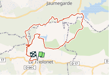

Length
13.5 km

Max alt
374 m

Uphill gradient
388 m
Km-Effort
18.7 km

Min alt
179 m

Downhill gradient
389 m
Boucle
Yes
Creation date :
2016-03-09 00:00:00.0
Updated on :
2016-03-09 00:00:00.0
4h52
Difficulty : Unknown

FREE GPS app for hiking
 SityTrail
IGN / Geographical institutes
SityTrail Plus
The world is yours!
About
Trail Other activity of 13.5 km to be discovered at Provence-Alpes-Côte d'Azur, Bouches-du-Rhône, Le Tholonet. This trail is proposed by aljac.
Positioning
Country:
France
Region :
Provence-Alpes-Côte d'Azur
Department/Province :
Bouches-du-Rhône
Municipality :
Le Tholonet
Location:
Unknown
Start:(Dec)
Start:(UTM)
702864 ; 4821831 (31T) N.
Comments